| Further Reading | The 3 Biggest Medieval Kingdoms In Europe |
For the past 20,000 years, man has been exploring the earth. As these early explorers journeyed across the world they would record their journeys in the form of drawn journals; these were the world’s first maps. Here are the top 6 oldest maps ever discovered.
While there are many artifacts that historians and archaeologists have proposed as ancient maps there are 6 that stand out.
- The 25,000 BC Pavlov mammoth tusk map
- A 14,000 BC sandstone cave etching in Spanish Navarre
- The Saint-Belec Slab dated between 2,500-1,600 BC
- The 1,500 BC Babylon map of the city of Nippur
- A 1,150 BC Egyptian Map of sandstone mines
- The 900 BC Babylonian map of the known world
These ancient maps were created to help guide people to geographic locations around them. The early maps were simply created to help track animal migratory patterns or guide people as to places to avoid. Later on as technology improved the maps became more accurate and started to resemble what we would call modern maps.
Here at The History Ace, I strive to publish the best history articles on the internet. If in the end, you enjoyed this article then consider subscribing to the free newsletter and sharing around the web.
Let’s jump right into it; below are the world’s 5 oldest maps.
1.) The 25,000 BC Pavlov Mammoth Tusk Map
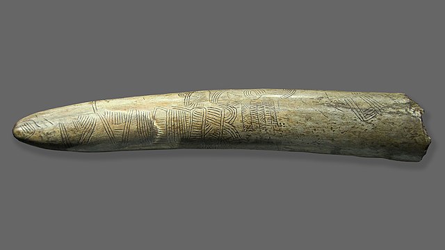
By far the oldest map found so far by field archaeologists and historians is the 25,000 BC map found at the Pavlov I archeological site in the Czech Republic.
The archeological site itself is of an ancient hunter-gather camp of humans who existed during the Upper Palaeolithic. The camp itself existed for nearly 2,000 years and during this time saw hundreds of families living there. Among the hundreds of artifacts recovered from this excavation one stands out above all others; a giant map created on a mammoth tusk.
This map is dated to around the year 25,000 BC and it is inscribed on an ivory mammoth tusk. The map itself appears to detail the nearby river Thaya with the camp’s location represented as two dots. Around this camp appears to be paths that lead away possibly to hunting locations.
This was an amazing find as it demonstrated that humans were aware of their geographical location and more importantly saw a need to document locations for themselves and others. Unfortunately, we only have only found the tip of the mammoth tusk. If we had rest we might be able to find out the true purpose of the ancient map.
Currently this mammoth tusk from Pavlov I is the world’s oldest map. In the future, we might uncover another older map but for now, this is what we got.
2.) A 14,000 BC Sandstone Cave Etching in Spanish Navarre
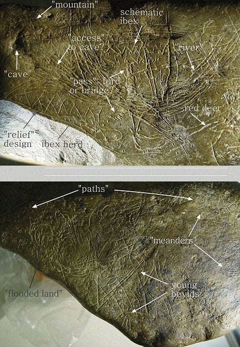
Let’s fast forward from the tusk map by about 10,000 years. At this point, man had started to take shelter in large groups in caves. Located in modern the modern Navarra region of Spain researchers found a sandstone block in the ancient Abauntz Cave in 1994 that dated to 14,000 BC!
For about 10 years archeologists and historians disregarded this sandstone block and stowed it away. However, in 2009 a study published in the Journal of Human Evolution took another look at the sandstone block and discovered that it was a map!
This map demonstrated the capacity of ‘cavemen’ to understand their spatial awareness and document their location and hunting grounds. This was an amazing find as it clearly demonstrates a local cartographic map that outlined where the cave people could hunt for deer and find water.
It is believed that this handheld sandstone map is one of the world’s oldest maps that demonstrate a local area. A caveman could leave on a hunt, record the hunt, and then use the map to find their way back to the home cave.
3.) The Saint-Belec Slab Dated Between 2,500-1,600 BC
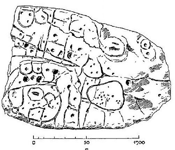
In the late 19th century the French archeologist Paul du Chatellier was excavating an ancient burial ground and found the Saint-Belec slab. At first, Chatellier thought nothing of this find. Taking it back to his home the rock stayed there for over 100 years until it was donated to the National Archeological Museum in France.
In 2014 the slab was rediscovered in the basement of the French National Archeological Museum. This find bewildered the team tasked with going through the museum’s old collections. Here was a massive rock about two meters in size with large inscriptions.
In 2017 a team of researchers began to look at the rock again and with the help of Chatelliers journal discovered something amazing. This massive rock was a detailed report of political power and land holdings. On the rock, itself was a series of circles and squares which represented land holdings around the Odet Valley of France.
The map itself even had variations in the surface of the rock to represent hills, valleys, and mountains. In all the rock was an incredibly detailed cartographic map of the 25th century BC Odet Valley of France. This map drew out the holdings of a power chieftain that controlled around 247 square miles!
The Saint-Belec slab remains one of the oldest territorial and political maps ever found in western Europe.
4.) The 1,500 BC Babylon Map of the City of Nippur
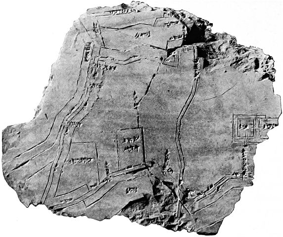
Fast forward another 1,000-500 years and the next oldest map that we have is the Babylonian map of the ancient city of Nippur. We actually have two maps of this city from the same time period (1,500-1,400 BC) which survive to the modern day!
The Babylonians were the first group of people to practice precise surveying techniques. This allowed Babylonian scribes to create highly detailed maps of entire cities or regions. Today some of the ‘best’ old maps that we have ever found came out of excavations in modern Iraq and date to the time of ancient Babylon.
The map of the city of Nippur is by far the oldest quality one that survives. Dated to the year 1,500 BC and drawn on a clay tablet this map provides a highly detailed top-down map of the boundaries of the ancient city of Nippur.
The map, which is pictured above, has a series of temples on the bottom left that are surrounded by high walls. In the middle of the map runs a manmade canal that brought water to the city, and on the far right is the main temple.
5.) A 1,150 BC Egyptian Map of Sandstone Mines
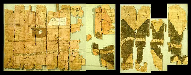
Around the same time as the Babylonians were making their maps, the ancient Egyptians were starting to document their geographic locations. However, instead of making maps to document cities and religious locations, the Egyptians were making maps of mining operations.
The oldest Egyptian map that we have is dated to around the year of 1,500 BC. Today this map is called the Turin Papyrus Map and it details where the Egyptians would get their sandstone from.
This map was created for the Egyptian Pharoh Ramesses IV. The purpose of this map was to inform Ramesses IV as to where the sandstone was being mined from for his statues. On top of this, there were several mentions of gold being discovered in the sandstone mines as well.
Because of this, the Egyptian Turin Papyrus Map is one of the first maps in history to be a geological map. This is because the purpose of the map was to inform people as to what minerals were located where. In this case, the Egyptians built this map to highlight sandstone and gold in the Nile river region of Egypt.
This map is drawn on a series of papyrus papers. It is about 6 feet long and about 2 feet wide. On the left side of the map are the Egyptian mining operations and the right side details the route that the blocks would take to reach the sandstone craftsmen.
6.) The 900 BC Babylonian Map of the Known World
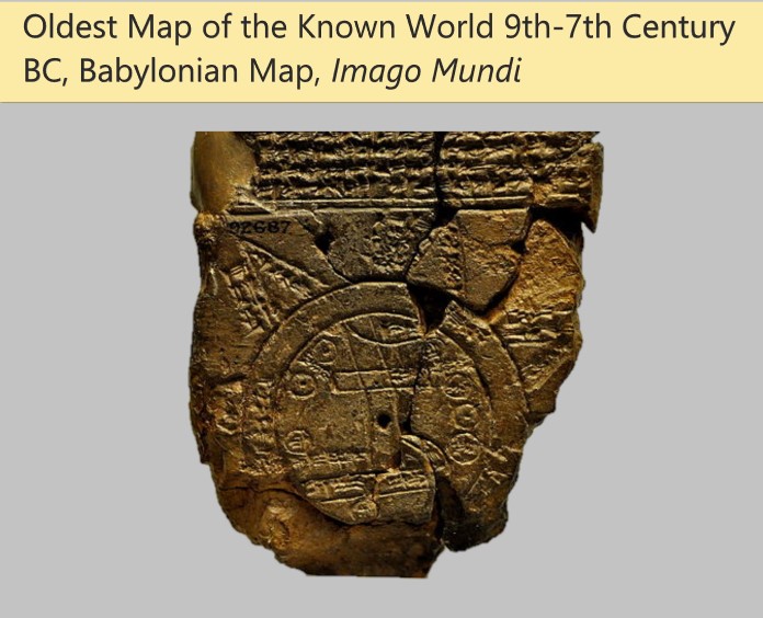
When it comes to the oldest map of a person’s ‘known world’ the oldest is the Babylonian 9th-7th century BC map called Imago Mundi. This map details the Babylonian’s known world.
This tiny map was a handheld relic. It is sized at around 5 inches in length and 3 inches in height. The purpose of this map is unknown but it might have been used as a teaching tool for children to help them better understand the world around them.
In the center of the tablet is the empire of Babylon. This empire is the circle in the center. In the center of this circle is the drawing for the Euphrates river. Surrounding this river are several Babylonian cities. Outside of the center of the table is a circular river that encapsulates the Babylonian empire. Academics speculate that this could be the Mediterranean, Black, Caspian, and Persian seas.
Outside of this circle are a series of points that could either represent mountainous regions or further points of interest for potential explorers.
To this day archeologists and historians are perplexed as to the purpose of this map. Many people have tried to learn more about it but almost nobody can figure out its true intention. In 1995 another segment of the map was discovered but people have not studied this yet.
However, it still remains the oldest ‘world map’ in history.
Conclusion
There you have it; just about everything you would ever need to know about the world’s 6 oldest maps.
If you are interested in learning more about these maps then I suggest you look into potential graduate degrees studying them. Not many people are studying these maps and as such there are a ton of potential research opportunities available for curious people.
Here at The History Ace, I strive to publish the best history articles on the Internet. If you enjoyed this article then consider subscribing to the free newsletter and sharing it around the web.
Further, you can check out some of the other articles below.
-
The World’s 6 Oldest Maps
Here is a list of the worlds oldest maps ever made. Most people are not aware of just how important these maps are to history.